On the Trail
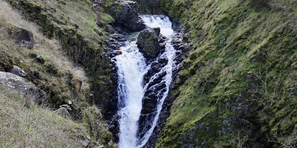
This easy, 1-mile, out-and-back hike begins at Totem Plaza on Mosier’s main street and climbs 150 feet along Mosier Creek to a viewpoint above Mosier Creek Falls. On warm days, play in the swimming hole at the base of the upper falls.
Permits & Pets
The trail and surrounding property are owned by the city of Mosier. Because the trail passes near private property and along cliffs, dogs should be leashed. No permits are required.
Trail Notes
- Begin the hike in town, at the 30-foot cedar totem pole. Its wildlife motifs were carved by lifelong Gorge resident Jeff Stewart, an art instructor at Columbia Gorge Community College in The Dalles.
- Turn left to walk east a short way, on the highway shoulder. Grab some drinks and snacks at the market, then continue east on the highway. Cross over Mosier Creek on a bridge designed in 1920 by the famous Oregon bridge engineer Conde McCullough, and restored in 2017. Mosier Creek and the town take their names from Jonah Mosier, who built a sawmill at the mouth of Mosier Creek in the 1850s.
- Just beyond the bridge, turn right onto a hiking trail into Mosier Pocket Park. Follow the trail along Mosier Creek past the Mosier Pioneer Cemetery, with graves from as early as the 1860s. Come to a viewpoint overlooking the canyon and upriver to Mosier Creek Falls. Continue through oak groves to the top of the waterfall. The horsetail-shaped falls drop 80 feet in two drops. Picnic here or swim in the swimming hole between the two cascades.
- Please always stay on the trail and clean your boots before and after you hike. Hikers are a common vector for spreading invasive seeds.
- Restrooms can be found in downtown.
Friends of the Columbia Gorge does not track trail closures. If you are planning a hike in the Gorge, please check other sources in advance for the latest updates, including the U.S Forest Service, Ready Set GOrge, and AllTrails. Recreational activities in the Gorge can involve risk of injury, death, property damage, and other dangers. Friends does not assume responsibility for any such outcome resulting from the use of the information on our hiking web pages. Your use of these web pages is strictly at your own risk.
Post-Hike Explorations
Drive east on scenic roads to wineries on State Road and Highway 30. They’re open for tastings April through October weekends. In June and July, many cherry orchards on Highway 30, State Road, and Root Road are open for U-pick. Bring a cooler and fill it up.
Have lunch or dinner in Mosier; walk its quiet, old residential streets; and enjoy the slow vibe of this charming Gorge town.
Other Hikes at or Near This Trailhead
Directions & Travel Tips
On I-84, take exit 69/Mosier and follow the exit road, the Historic Columbia River Highway, as it curves east into Mosier’s small business district. On the left is Totem Plaza. Just past the totem pole, turn left and park in the large gravel area downhill, between the highway and railroad tracks. A restroom is in the plaza.