On the Trail
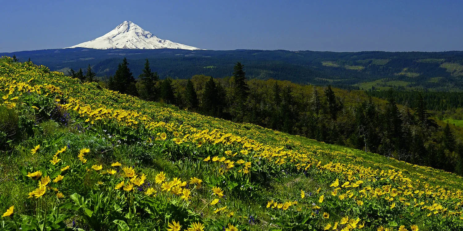
For 1.5 miles, this hike climbs steadily 1,030 along cliffs to Tom McCall Point and returns the same way, for a total of 3 miles. Views of wildflowers, Cascade peaks, and a wide swath of the rocky cliffs that line the Columbia will slow your pace and give your camera a workout.
Pair this hike with a nearby easy walk on Rowena Plateau. Both are within the 231-acre Tom McCall Preserve at Rowena, land protected by The Nature Conservancy.
This hike is closed seasonally, November 1 through April 30.
Permits & Pets
Rowena Plateau is managed by Oregon State Parks. Tom McCall Nature Preserve is managed by The Nature Conservancy. No permits are required. Dogs are not allowed, on- or off-leash.
Trail Notes
- The trail begins on the south side of the paved Rowena Crest overlook loop. Cross a flat area for 0.1 mile, then follow an old road to an intersection with another old road, likely the wagon road built from The Dalles to Hood River in the 1870s.
- Come to a sign for “Tom McCall Point Trail.” The trail leaves the wagon road and after a short climb reaches meadows overlooking Rowena Plateau. Here are big views west, including the arched Dry Canyon Creek Bridge and Mount Defiance.
- To the north, Mt. Adams appears beyond Lyle. From here, the trail steepens and switchbacks through forests of scrub oak and open grassy areas. Views of the river and plateau get better and better.
- At the summit, Mt. Hood caps the already fantastic views. From here, an optional, fainter trail continues south, dropping steeply into a little saddle and climbing the peak beyond. This part of the trail is narrower, steeper, and more prone to poison oak than the first part.
- After about another 0.5 mile, reach the second summit, marked by a small rock cairn. The area is covered in small oak trees, with open viewpoints here and there in all directions.
- Ticks and poison oak are present here. Long sleeves and pants, tucked in, are a good strategy.
- Please always stay on the trail and clean your boots before and after you hike. Hikers and their dogs are common vectors for spreading invasive seeds.
- There are no restrooms at the trailhead.
Friends of the Columbia Gorge does not track trail closures. If you are planning a hike in the Gorge, please check other sources in advance for the latest updates, including the U.S Forest Service, Ready Set GOrge, and AllTrails. Recreational activities in the Gorge can involve risk of injury, death, property damage, and other dangers. Friends does not assume responsibility for any such outcome resulting from the use of the information on our hiking web pages. Your use of these web pages is strictly at your own risk.
Post-Hike Explorations
After this hike, don’t miss the easy Rowena Plateau hike, accessed from the same parking area. Then, explore a bit farther east on the Historic Highway, descending off the plateau on the beautiful Rowena Loops, constructed in 1919. Like the loops that lift travelers up to Crown Point at the Gorge’s west end, this graceful stretch of roadway lies upon the land like a ribbon carefully arranged to complement the cliffs.
East of the last loop is Rowena Ferry Road, named for the ferry that once crossed the Columbia between Rowena and Lyle. Explore a decaying remnant of this road and other sites at Mayer State Park: Once down from the Rowena Loops, turn left in the town of Rowena at the freeway exit. Instead of going right to head east on I-84, go left to pass under it and onto Rowena River Road. Follow it 0.8 mile east to a day use area for windsurfers.
After exploring here or watching the action, go west on the same road; once past the freeway intersection, the road is Rowena Ferry Road. Continue west. Pass a boat ramp, park along the road, and walk to a rare, warm-water (relatively speaking) pond with sandy beaches. Like the features on Rowena Plateau, it’s a kolk pond. A trail west of the lake leads to sand dunes and a small beach on the Columbia.
Head back to the Historic Highway and follow it east 10 scenic miles to The Dalles for lunch or dinner in its historical downtown, or a stop at the Columbia Gorge Discovery Center & Museum.
Other Hikes at or Near This Trailhead
Directions & Travel Tips
On I-84, take exit 69/Mosier, and exit onto the Historic Columbia River Highway. With no restrooms at the trailhead, a stop at Mosier Totem Plaza makes a good restroom break. From the plaza, continue east on the highway 6.3 miles and turn right into the Rowena Crest overlook.