The Columbia River snakes through this spectacular canyon on its westward journey before joining the Pacific Ocean. Nowhere else on earth exists such a wonder of desert and forest, cliffs and waterfalls, sun and rain. It’s the only place in the world where a mighty river crashes through an entire mountain range.
Explore
Wonders of the Columbia Gorge
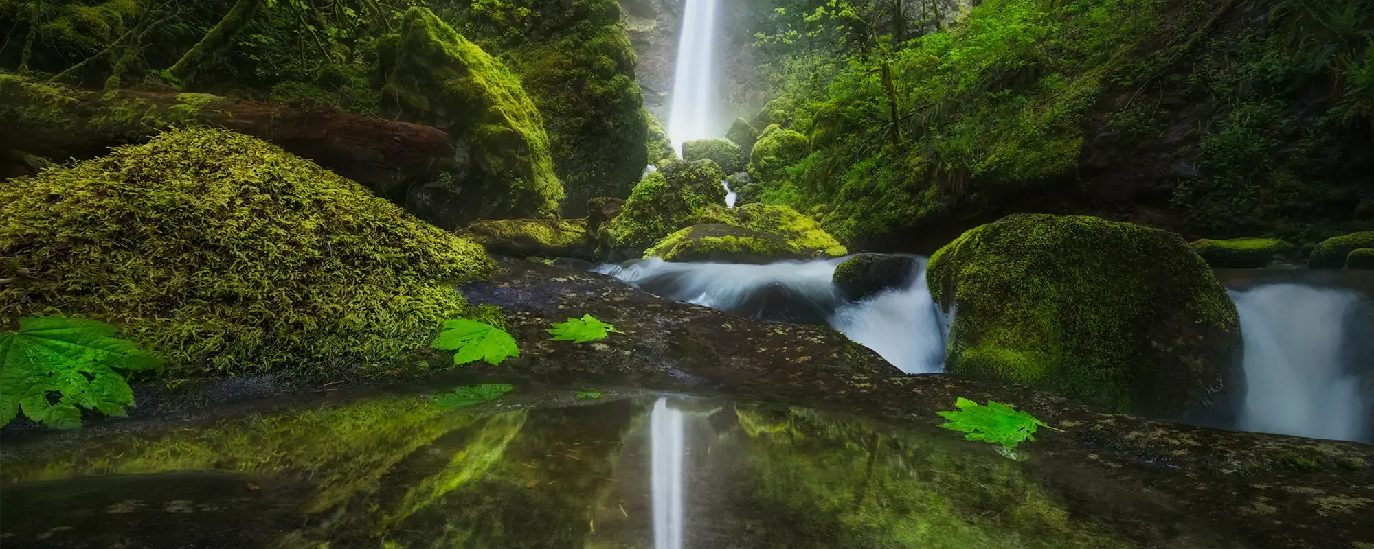
The Columbia Gorge is one of our planet’s most stunning places.
The Gorge stretches 85 miles from its eastern edge at the confluence of the Columbia and Deschutes rivers to the westward edge of the Portland metro area. The Columbia River divides Oregon and Washington, yet here it unites millions of people drawn to the Gorge’s remarkable natural and cultural riches.
Geological History
The Gorge was crafted over eons, even before the Cascades rose, and its cataclysmic history of volcanic eruptions, massive floods, and landslides is still evident today. The Gorge’s formation began 40 to 60 million years ago, when molten lava pressure pushed up granite to frame the Columbia Basin.
Between 6 to 17 million years ago, ancient volcanoes erupted, streaming more than 20 massive basalt flows into the area that’s now the Gorge. They formed rock layers up to 2,000 feet thick, cutting the canyon and becoming most of the rocks in the Gorge today.
Then glacial Ice Age floods sculpted the canyon into a gorge. About 40 Missoula floods — the planet’s largest known floods during the last two million years — generated water flows 10 times the total flow of all Earth’s rivers. They transformed river tributaries into the world’s largest concentration of waterfalls: about 80 named falls, including famous 620-foot Multnomah Falls, the United States’ second-highest year-round waterfall.
The Columbia River, the only sea-level route through the Cascades, still carves canyon walls that can soar 4,000 feet. Rock pillars jut from the river, monoliths perch atop cliffs, and smaller canyons branch off from the Gorge. Surrounding mountains reach even higher, including Mount Hood to the south of the Gorge and Mount St. Helens to the north. Both are active volcanoes, and Mount St. Helens’ 1980 eruption remains the country’s deadliest.
Natural Wonders
Beyond the iconic canyon and glittering river, the Gorge boasts extraordinary landscapes, habitats, and biodiversity. A range of ecosystems and micro-habitats extend along its length, from arid grasslands in the east to temperate rainforests in the west. And as the land rises from river to mountaintops, riparian areas and wetlands transition to alpine crags and meadows.
These wild places support astonishing biodiversity, including:
- More than 800 species of plants, including 15 species of wildflowers that exist nowhere else in the world
- Approximately 45 species of fish, including shad, lamprey, sturgeon, steelhead, and chinook, coho, and sockeye salmon
- 15 species of amphibians and reptiles, including salamanders, tree frogs, turtles, lizards, and snakes
- More than 200 species of birds, including spotted owls, bald eagles, and migratory waterfowl and songbirds traveling the Pacific Flyway
- More than 20 species of mammals, including pika, deer, marmots, coyotes, bobcats, and black bears
- About 25 threatened or endangered plant and animal species, including 12 stocks of salmon and western pond turtles
- Two glacier-fed, federally designated Wild and Scenic Rivers — the Lower White Salmon and the Lower Klickitat — that flow through the Gorge, providing fish and wildlife habitat as well as scenery and recreation.
Cultural Wonders
With Native Americans as the Gorge’s first residents and stewards, the Gorge’s human history stretches back 10,000 to 15,000 years. For millennia, Native Americans made their homes, traveled, and traded along the river. Tribes from around the Pacific Northwest gathered to fish at Celilo Falls.
Today, the National Scenic Area recognizes four treaty Tribes — the Confederated Tribes of Warm Springs, the Confederated Tribes and Bands of the Yakama Nation, the Confederated Tribes of the Umatilla Indian Reservation, and the Nez Perce Tribe — in its legislation and Management Plans. In addition, federal state agencies also consult with recently recognized Tribes, including the Confederated Tribes of Grand Ronde and the Cowlitz Indian Tribe.
The Gorge was a natural travel corridor for Native Americans — and later, for explorers, settlers, and traders from Europe and the eastern United States. In 1805-1806, Lewis and Clark famously explored and wrote extensively about the Gorge. Their expedition and others opened the area for thousands of Oregon Trail pioneers, who largely displaced Native people from their lands and communities.
Today the Gorge hosts 13 designated urban areas: Cascade Locks, Hood River, Mosier, and The Dalles in Oregon, and North Bonneville, Stevenson, Carson, Home Valley, White Salmon, Bingen, Lyle, Dallesport, and Wishram in Washington. And throughout the Gorge, museums, historic landmarks, and interpretive centers connect today’s thriving communities with the rich history of generations that came before and the ongoing cultural traditions and practices of regional tribes.
And it is Fragile…
While the Columbia Gorge remains an active commerce corridor, both by river and rail, it continues to change. The Gorge became a National Scenic Area in 1986 by an act of Congress to protect and enhance its scenic, natural, cultural, and recreational resources. The 292,000-acre Columbia River Gorge National Scenic Area is the United States’ largest and most populated scenic area, home to more than 75,000 people. Native Americans still celebrate their traditions rooted in the Gorge and shape the area’s future, including by working to protect natural, cultural, and scenic assets.
Millions of people visit the National Scenic Area’s magnificent landscapes each year. Recreational opportunities abound, including:
- Observing salmon navigate fish ladders along one of the world’s greatest migrations
- Kiteboarding and windsurfing in Hood River, one of the world’s best wind sports destinations
- Hiking trails and routes that stretch more than 200 miles through the Gorge, including sections of the Pacific Crest Trail and the Lewis and Clark National Historic Trail
- Visiting wildlife refuges and 21 state parks and recreation areas
- Using transportation options along the Columbia River Highway, the United States’ first scenic highway and a national historic landmark that curves 70 miles through the Gorge
- Biking, kayaking, rafting, fishing, camping, and birdwatching
The Gorge has a special meaning to millions of people. It feeds our souls and speaks to the history of those who came before us. It’s a sanctuary for species that live nowhere else.
And it is fragile.
These wonders still face threats: development, fossil fuel transport, climate change, and even visitation. Ensuring that the Gorge remains a vibrant, living place—wondrous, wild, and open to all—is at the core of what Friends of the Columbia Gorge does.
Get involved with our work to protect, preserve, and steward the Gorge for future generations. Find out how to stay updated, volunteer, or give.
Latest News
Keep updated on Friends' work, news stories, and the work happening in the Columbia Gorge.

An Interview with Gabe Sheoships, Friends’ New Executive Director
May 4, 2026
Get to know Gabe Sheoships, Friends' new executive director, through this conversation with Acting Public Engagement & Communications Director Melissa Gonzalez, exploring his connection to the Gorge, his background, and the person behind the role.
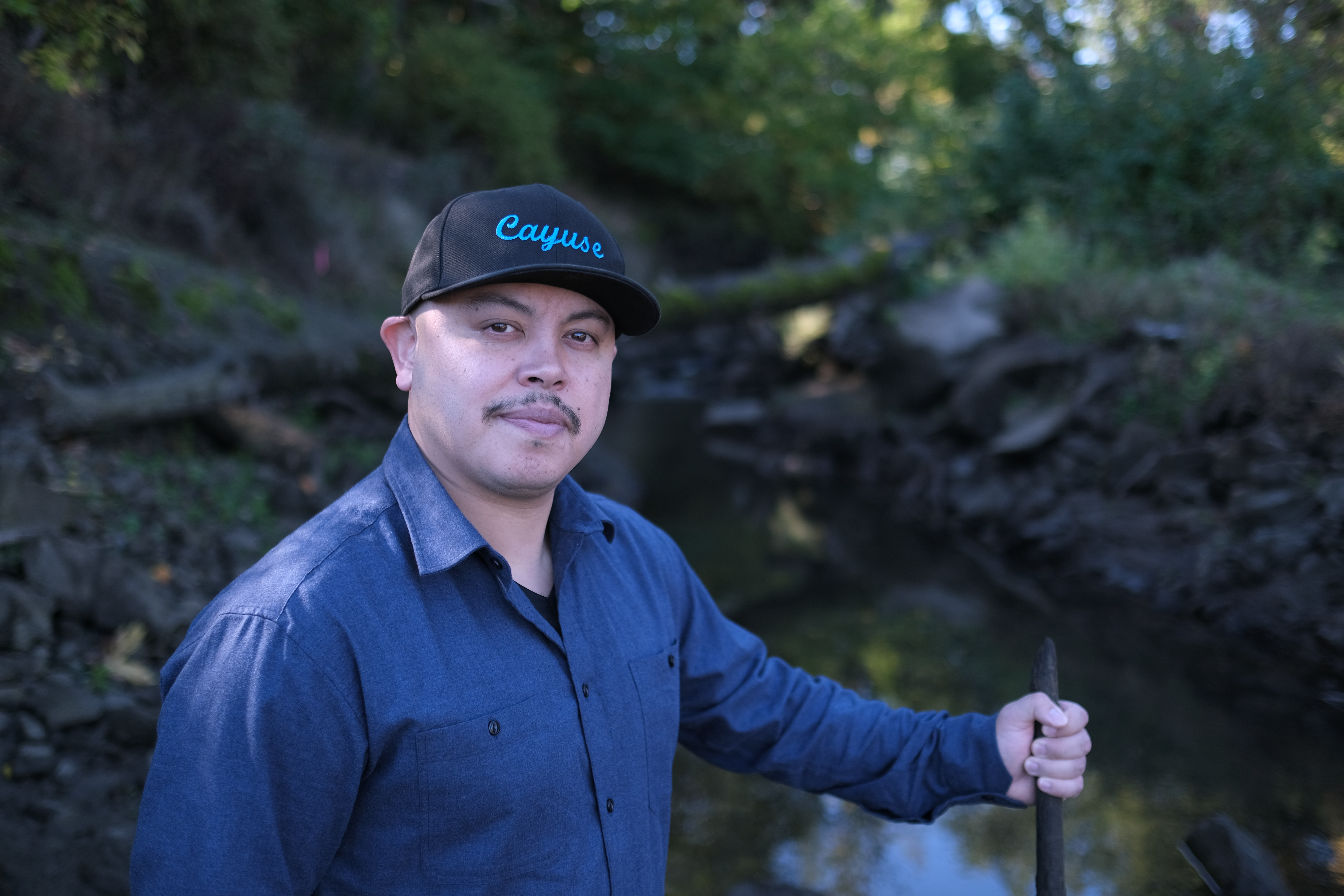
Gabe Sheoships. Photo by Alex Milan Tracy, Underscore News.
Friends of the Columbia Gorge Announces Gabe Sheoships as New Executive Director
April 7, 2026
PRESS RELEASE Sheoships is Cayuse and Walla Walla, an enrolled citizen of the Confederated Tribes of the Umatilla Indian Reservation, and becomes the first enrolled member of a Gorge Treaty […]
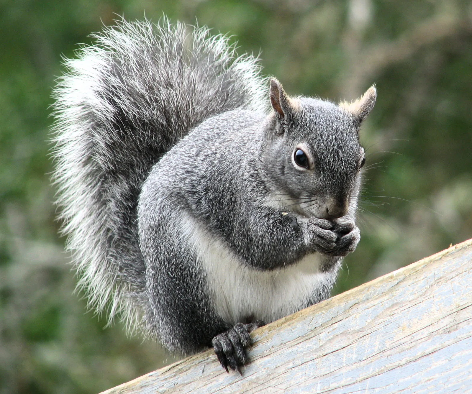
Photo Courtesy of Larry McCombs.
Appeals court ruling sets stage for protection of western gray squirrel in Washington state
February 20, 2026
A decision by the Washington State Court of Appeals on February 9, 2026, adds significant momentum to efforts to protect the state-endangered western gray squirrel in Washington, particularly in Klickitat County. The appeals court decision also highlights the ongoing failures of the Washington Department of Natural Resources to comply with the law and propose critical habitat for this imperiled species, as required by state law.