The Columbia Gorge is a truly remarkable place. From rainforests to dry grasslands, it has the highest concentration of waterfalls in North America, and is home to countless species of birds, fish, and plants—including 15 species of wildflowers that exist nowhere else in the world.
Explore
The Columbia River Gorge National Scenic Area Act
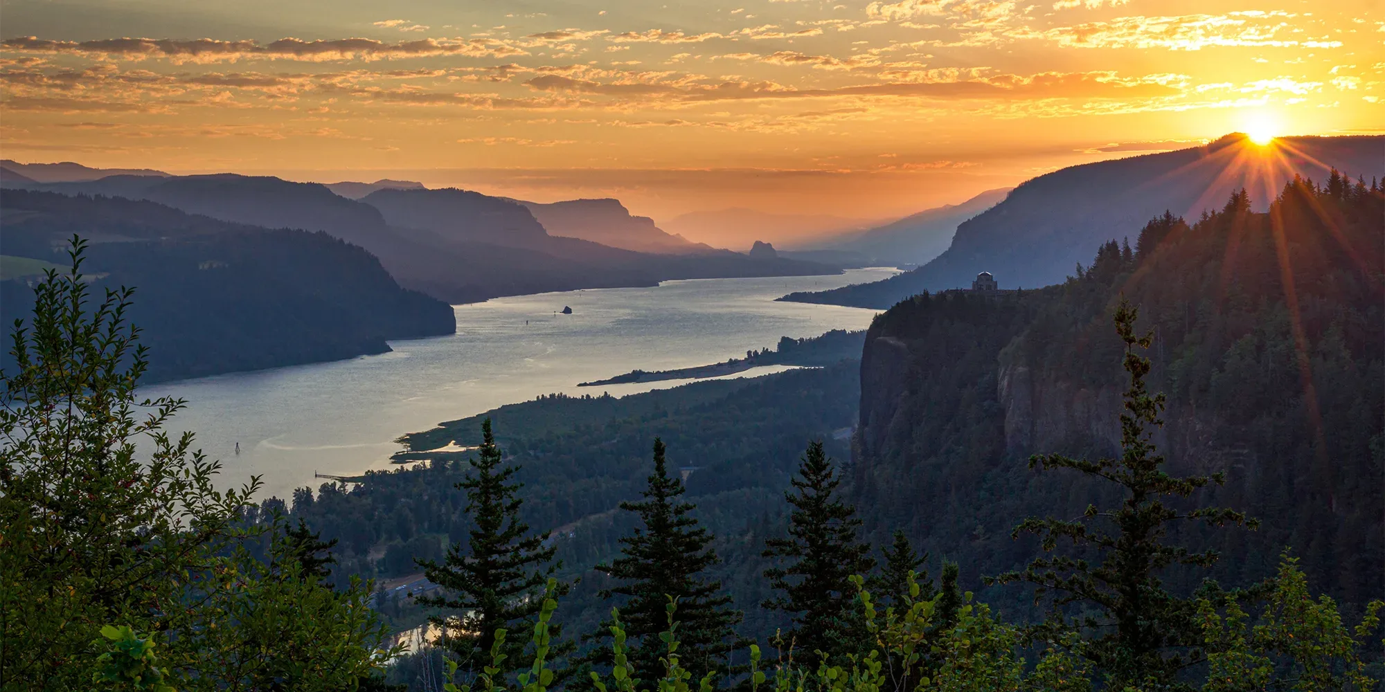
Sunrise from the Portland Women's Forum Scenic Viewpoint. Photo by Chris Elkinton.
The Gorge’s beauty and its delicate balance of nature with community are why many choose to live there and in the areas that surround it. But the pressures of development have been and continue to be a threat to this balance.
For over four decades, Friends of the Columbia Gorge has worked with community partners to help ensure the Gorge remains a healthy and vibrant place for the people and wildlife that live there. Our first effort was Friends’ successful campaign to enact permanent federal protections that would protect the Gorge for future generations.
Crafting and Passing of the Columbia River Gorge National Scenic Area Act
From 1980 to 1986, Friends worked on the arduous task of building political support that would ultimately lead to the creation of a national scenic area including both sides of the Columbia Gorge. There were nine major state and federal hearings in Oregon, Washington, and Washington, D.C. Friends worked closely with the congressional delegation to craft a series of bills that would establish the Columbia River Gorge National Scenic Area. Major economic and resource development interests organized vigorous opposition. At the same time, leaders in Congress, including Oregon Senator Mark Hatfield, worked with Friends and allies across partisan and state lines to build support, both in the Pacific Northwest and on Capitol Hill.
The campaign to create new federal protections for the Gorge eventually prevailed, and the Columbia River Gorge National Scenic Area Act was finally passed by both the U.S. Senate and House in October 1986. The bill was signed by President Reagan on November 17, 1986, with help from a last-minute nudge by Sen. Hatfield, just hours before the bill would have died from a pocket veto.
National Scenic Area FAQs
This is a broad overview of the Scenic Area Act:
What is a National Scenic Area? A National Scenic Area is a federally designated area of natural and scenic value that receives less protection than a Wilderness Area. A National Scenic Area is generally already populated by people, or is considered suited for uses in addition to wilderness.
How many National Scenic Areas exist? There are currently ten designated National Scenic Areas. Although it was not the first National Scenic Area (Mono Basin in California was designated in 1984), the Columbia River Gorge National Scenic Area is the largest and most well-known National Scenic Area, visited by approximately 2 million people annually.
What is the purpose of the Columbia River Gorge National Scenic Area Act? The National Scenic Area Act has two purposes:
- To protect and enhance the scenic, cultural, recreational, and natural resources of the Gorge
- To protect and support the economy of the Gorge by encouraging sustainable growth in existing urban areas and by allowing future economic development in a manner that is consistent with the first purpose
The second purpose—encouraging economic growth—must be carried out in a manner that serves the first purpose: protecting and enhancing Gorge resources.

How large is the Columbia River Gorge National Scenic Area? The National Scenic Area consists of approximately 293,000 acres located in Multnomah, Hood River, and Wasco Counties in Oregon and Clark, Skamania, and Klickitat Counties in Washington. The Scenic Area stretches for 85 miles from west to east—from the Sandy River Delta to the Deschutes River in Oregon and from Gibbons Creek to east of Wishram in Washington. It’s one to four miles wide across the Columbia River, in many locations spanning from the ridge line in Washington to the ridge line in Oregon.
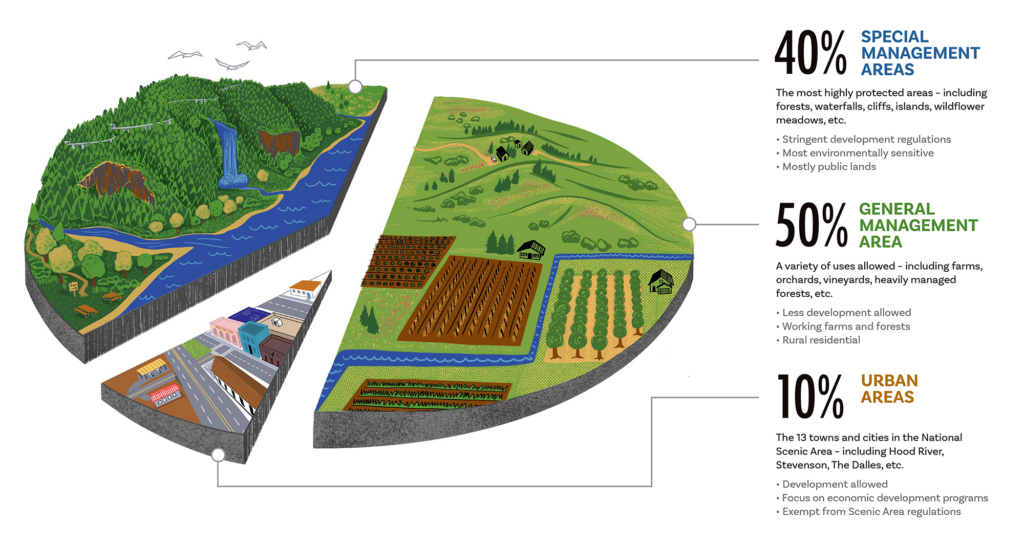
Chart delineating the designated zones within the Columbia River Gorge National Scenic Area. (designed by Audrey Desler for Friends of the Columbia Gorge)
How does the Scenic Area Act address the towns and cities in the Gorge, as well as private land ownership? The Scenic Area Act divides the Scenic Area into three broad categories of land areas, each with different requirements for land use regulations:
- Urban Areas (approximately 10 percent of total acreage): These 13 towns and cities are the focus of economic development programs and are exempt from the regulations adopted in accordance with the National Scenic Area lands.
- Oregon: Cascade Locks, Hood River, Mosier, The Dalles.
- Washington: North Bonneville, Stevenson, Carson, Home Valley, White Salmon, Bingen, Lyle, Dallesport, Wishram.
- Special Management Areas (approximately 40 percent): These are the most sensitive and stringently managed lands within the National Scenic Area, located mainly within the western half. The U.S. Forest Service is authorized to purchase, at fair market value, certain sensitive lands from willing sellers in Special Management Area-designated areas, or to trade federal lands elsewhere for privately owned forestland with Special Management Area designations. The Forest Service has the authority to write the Management Plan regulations for the Special Management Areas.
The Columbia River Gorge National Scenic Area has acquired over 41,000 acres of public lands since 1986. Roughly half of those acres have been purchased, and slightly less than half have been acquired through land exchanges.
Who oversees the National Scenic Area to ensure its protection? The Scenic Area Act authorized Oregon and Washington to enter into a bi-state compact that created the Columbia River Gorge Commission. The Scenic Area Act delegates authority to the Gorge Commission and the Forest Service to adopt and implement a Gorge Management Plan that regulates land use in the National Scenic Area (excluding Urban Areas). The Gorge Commission writes the rules for the General Management Area and oversees land use and development on private and state lands, while the Forest Service writes the rules for the Special Management Areas and oversees all federal activities. Gorge counties are authorized to adopt and enforce land use ordinances that implement the Gorge Management Plan, subject to oversight by the Gorge Commission and Forest Service.
Who makes up the Gorge Commission? The Commission is a 13-member regional body representing federal, state, and local interests. Six of its members are appointed by the county commissions of each Gorge county. The Oregon and Washington governors each have three appointments, and at least one of these appointments in each state must reside in the National Scenic Area. The thirteenth member is a non-voting designee of the U.S. Secretary of Agriculture. Since the Commission’s inception, that seat has been filled by the Forest Service’s National Scenic Area Manager or Acting Manager.
Latest News
Keep updated on Friends' work, news stories, and the work happening in the Columbia Gorge.

An Interview with Gabe Sheoships, Friends’ New Executive Director
May 4, 2026
Get to know Gabe Sheoships, Friends' new executive director, through this conversation with Acting Public Engagement & Communications Director Melissa Gonzalez, exploring his connection to the Gorge, his background, and the person behind the role.

Gabe Sheoships. Photo by Alex Milan Tracy, Underscore News.
Friends of the Columbia Gorge Announces Gabe Sheoships as New Executive Director
April 7, 2026
PRESS RELEASE Sheoships is Cayuse and Walla Walla, an enrolled citizen of the Confederated Tribes of the Umatilla Indian Reservation, and becomes the first enrolled member of a Gorge Treaty […]

Photo Courtesy of Larry McCombs.
Appeals court ruling sets stage for protection of western gray squirrel in Washington state
February 20, 2026
A decision by the Washington State Court of Appeals on February 9, 2026, adds significant momentum to efforts to protect the state-endangered western gray squirrel in Washington, particularly in Klickitat County. The appeals court decision also highlights the ongoing failures of the Washington Department of Natural Resources to comply with the law and propose critical habitat for this imperiled species, as required by state law.