On the Trail
This hike travels deep into the Eagle Creek canyon, beyond popular Punch Bowl Falls, beyond High Bridge, and on to a spectacular tunnel carved behind a 172-foot-tall waterfall. The route is 12 miles round trip and gains 1,640 feet in elevation. The hike to Tunnel Falls is one for the bucket list, but not for young children, because of its narrow passage, in places, alongside very high cliffs.
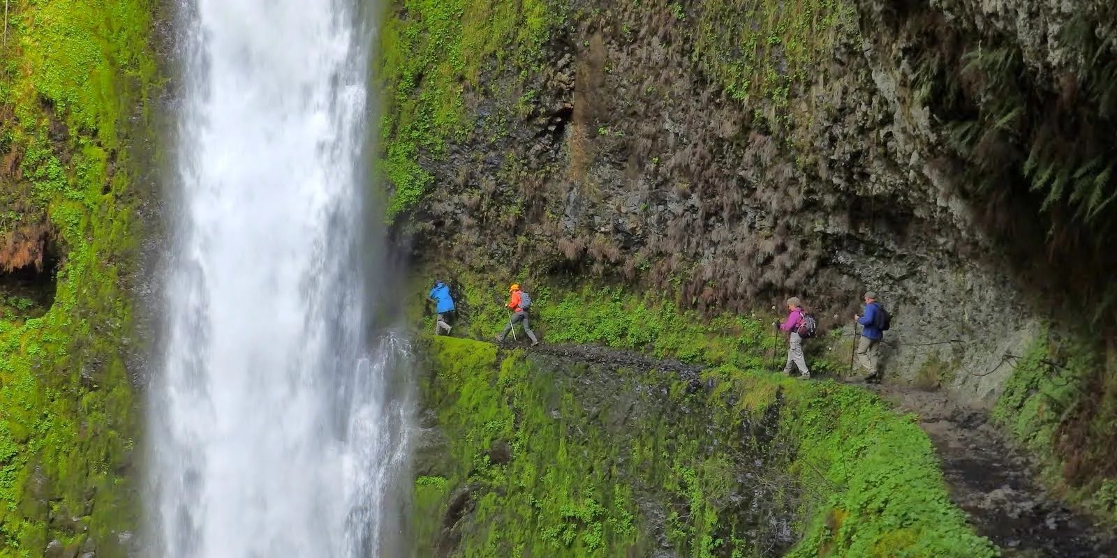
Since it was blasted out of sheer cliffs a century ago, the Eagle Creek Trail (Trail 440), with its waterfalls, high cliffs, and old-growth forest, is one of the most popular hikes in the Columbia River Gorge.
Permits & Pets
The site is managed by the U.S. Forest Service. A Northwest Forest Pass is required to park. Pay $5 cash at the trailhead kiosk, or, purchase one in advance. This hike enters the Mark O. Hatfield Wilderness. Wilderness restrictions apply.
Dogs are required to be on a leash no longer than 6 feet at all times. However, we do not recommend taking dogs on this hike.
Trail Notes
- Begin at the trailhead at road’s end. Within 0.5 mile, the trail climbs high above the creek. In places, it is narrow with a very steep drop-off. Hold onto the cables that run along the trail where it hugs the cliffs.
- In 1.9 miles, come to a signed junction for Punch Bowl Falls. Either take the trail downhill about 300 feet to Lower Punch Bowl Falls, a 12-foot-high falls that’s popular with swimmers, or scramble along the shoreline (or swim the creek) upstream to Punch Bowl Falls, with its 33-foot drop and elegant pool, the subject of countless photographs.
- If you stay on the main trail, in about 0.25 mile come to the Punch Bowl Falls Overlook. It offers a view of the falls from above.
- Continuing onward, the trail swings away from Eagle Creek’s gorge, then emerges back into it high above the creek bed. Watch for horsetail-shaped Loowit Falls on the opposite bank. It drops 88 feet from a tributary stream into a pool before spilling into Eagle Creek.
- From here, the trail leads next to High Bridge. Although wide and well groomed, the trail is rocky and can be slippery, and is at the edge of a 120-foot-high cliff. A cable affixed to the rock wall provides some security. Pass others with care, and keep any dogs on a very short leash.
- High Bridge is aptly named: It spans a narrow channel 120 feet above the creek. For lunch, sit at one of the often-crowded viewpoints near the bridge or walk another hundred yards to Tenas Camp and find a quiet spot to sit, or camp.
- Continuing on to Tunnel Falls: Beyond High Bridge, at 4.5 miles cross Eagle Creek on the low Four and a Half Mile Bridge, a nice spot to cool off on a hot day. Over the next few miles pass through campsites. When crossing over Wy’East Creek, a tributary to Eagle Creek, look left for ribbon-like Wy’East Falls, a 20-foot-wide fall that plunges 157 feet. Next, come to Wy’East Camp, a large campsite.
- Pass into the Hatfield Wilderness. Hikers are required to fill out a free permit here. Cross two enormous talus slopes, then a section called the Potholes, and finally come to Tunnel Falls. The 172-foot-high waterfall drops into a large, bowl-like amphitheater sculpted into the columnar basalt. It’s on the east fork of Eagle Creek, the creek’s largest tributary. Its headwaters are Wahtum Lake.
- The name comes from the tunnel carved by early trail builders behind the falls. The trail curves around the falls, allowing for great viewing from many angles. Go on through, and hang onto the cable along the path.
- Retrace your steps to the trailhead.
- Please always stay on the trail and clean your boots before and after you hike. Hikers are a common vector for spreading invasive seeds.
- On the road to the trailhead, restrooms are to the left, adjacent to a parking area.
Post-Hike Explorations
After a day hiking this beautiful canyon, food and drink may be your highest priority. The nearest brewpubs and restaurants are in Cascade Locks, 3 miles east on I-84, at exit 44.
Other Eagle Creek Trail Hikes from This Trailhead
- To Punch Bowl Falls: 3.8 miles, out-and-back, 600 feet of gain
- To High Bridge: 6.2 miles, out-and-back, 970 feet of gain
- To Wahtum Lake: 25.5 miles, out-and-back, 5,210 feet of gain
Directions & Travel Tips
Eastbound I-84: Take exit 41/Eagle Creek. At the end of the ramp, turn right, and drive 0.6 mile along Eagle Creek to the parking area and trailhead at road’s end. Park only in designated spaces. If the parking area is full, turn around and park in the large lot near the restroom and fish hatchery. This will add about 1 mile (round trip) to the hike.
Westbound I-84: There is no exit, so take exit 40/Bonneville Dam; turn left to cross over I-84 and then left onto the eastbound ramp to I-84. In 1 mile, take exit 41/Eagle Creek, and follow directions above.