On the Trail
This 3.8-mile, out-and-back hike gains 600 feet of elevation as it travels to the first significant waterfall of Eagle Creek’s spectacular series of falls. Although an easy hike, it’s not suitable for young children because of the narrow trail alongside very steep cliffs.
Since it was blasted out of sheer cliffs a century ago, the Eagle Creek Trail (Trail 440), with its waterfalls, high cliffs, and deep forest, is one of the most popular hikes in the Columbia Gorge.
Permits & Pets
The site is managed by the U.S. Forest Service. A Northwest Forest Pass is required to park. Pay $5 cash at the trailhead kiosk, or, purchase one in advance. Dogs are required to be on a leash no longer than 6 feet at all times. However, we do not recommend taking dogs on this hike.
Trail Notes
- Begin at the trailhead at road’s end. Within 0.5 mile, the trail climbs high above the creek. In places, it is narrow with a very step drop-off. Hold onto the cables that run along the trail where it hugs the cliffs.
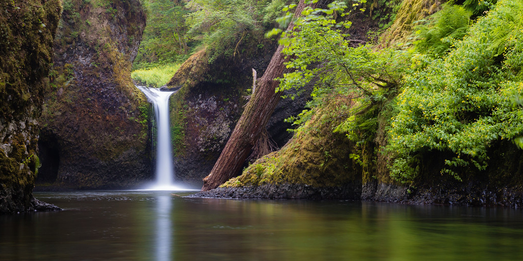
- In 1.9 miles, come to a signed junction for Punch Bowl Falls. Either take the trail downhill about 300 feet to Lower Punch Bowl Falls, a 12-foot-high falls that’s popular with swimmers, or scramble along the shoreline (or swim the creek) upstream to Punch Bowl Falls, with its 33-foot drop and elegant pool, the subject of countless photographs.
- If you stay on the main trail, in about 0.25 mile come to the Punch Bowl Falls Overlook. It offers a view of the falls from above.
- Please always stay on the trail and clean your boots before and after you hike. Hikers are a common vector for spreading invasive seeds.
- On the road to the trailhead, restrooms are to the left, adjacent to a parking area.
Friends of the Columbia Gorge does not track trail closures. If you are planning a hike in the Gorge, please check other sources in advance for the latest updates, including the U.S Forest Service, Ready Set GOrge, and AllTrails. Recreational activities in the Gorge can involve risk of injury, death, property damage, and other dangers. Friends does not assume responsibility for any such outcome resulting from the use of the information on our hiking web pages. Your use of these web pages is strictly at your own risk.
Post-Hike Explorations
From the trailhead, drive out the road along Eagle Creek. On the right is the Cascade Salmon Hatchery, built in the 1950s on the site of a roadhouse lodge and cabins that operated from 1915 to 1937. Take a self-guided tour of the coho salmon ponds (open 7:30 a.m. to 4 p.m.). Each year, millions of fingerlings raised here take a ride down I-84 on their way to new homes on land owned by the Umatilla, Nez Perce, and Yakama tribes. Other fingerlings have a shorter trip: They are shipped to nearby Herman Creek. A display on the building’s east side offers interesting information.
In fall, watch salmon return to spawn. Alongside the Historic Columbia River Highway, a fish-viewing platform was built in the 1910s for just that purpose. But good viewing sites are all along the creek, adjacent to the roadway. Fall weekdays are prime time for schoolchildren who bus in from around the region to learn about the salmon’s life cycle.
Other Eagle Creek Trail Hikes from This Trailhead
- To High Bridge: 6.2 miles, out-and-back, 800 feet of gain
- To Tunnel Falls: 12 miles, out-and-back, 1,640 feet of gain
- To Wahtum Lake: 25.5 miles, out-and-back, 5,210 feet of gain
Directions & Travel Tips
Eastbound I-84: Take exit 41/Eagle Creek. At the end of the ramp, turn right, and drive 0.6 mile along Eagle Creek to the parking area and trailhead at road’s end. Park only in designated spaces. If the parking area is full, turn around and park in the large lot near the restroom and fish hatchery. This will add about 1 mile (round trip) to the hike.
Westbound I-84: There is no exit, so take exit 40/Bonneville Dam; turn left to cross over I-84 and then left onto the eastbound ramp to I-84. In 1 mile, take exit 41/Eagle Creek, and follow directions above.