On the Trail
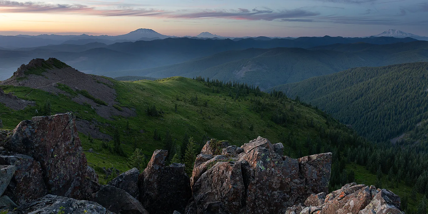
This 5-mile loop to Silver Star Mountain, one of the prominent peaks in southwest Washington, climbs 1,500 feet to the 4,390-foot summit. From atop the mountain are panoramic views of the western Gorge and five Cascade volcanoes. The fantastic wildflower show peaks in June and July.
Permits & Pets
This site is part of the Gifford Pinchot National Forest. No permits or passes are required. Dogs must be on leash.
Trail Notes
- Before heading out, carry a printed, current map with you to avoid a wrong turn, as there are many trails that connect in this area. A U.S. Forest Service recreation and trails map of the forest shows its parks, trails, and campgrounds.
- From the parking area, take Trail 180, which starts as a single-track dirt trail through a young maple forest. It soon comes to a former lookout access road; follow this road to the signed lower end of Ed’s Trail.
- From here, head left onto Ed’s Trail, taking you on the north side of the knoll to create a loop. This trail is more technical than the hike up to the summit on the former road — there is a large boulder to scramble onto. Hiking poles are highly recommended.
- Continuing on Ed’s Trail, pass under a natural rock arch and false summits, and then dip into the forest. Plenty of stunning views and wildflowers in June and July (after the snow melts) will demand your attention along the way.
- Just over 2 miles from the trailhead, come to a junction with the former road that you turned off of to hike Ed’s Trail. To make a loop, return this way, hiking downhill on the road. For now, turn left, heading uphill for 0.1 mile on the Silver Star Summit Trail.
- Please watch your footing, as the roadbed is rocky here. Come to another unmarked road junction. Turn left here and head up the rocky spur road toward the summit. Here, find remnants of the former fire lookout. Soak up the views in all directions of the Columbia River Gorge and five Cascade volcanoes (Mounts Adams, Helens, Hood, Jefferson, Rainier) on a clear day.
- Head down the mountain on the former road all the way back to your car to make it a loop hike. Or retrace your steps on Ed’s Trail.
- Please always stay on the trail and clean your boots before and after you hike. Hikers are a common vector for spreading invasive seeds.
- There is no restroom at the Ed’s trailhead.
Friends of the Columbia Gorge does not track trail closures. If you are planning a hike in the Gorge, please check other sources in advance for the latest updates, including the U.S Forest Service, Ready Set GOrge, and AllTrails. Recreational activities in the Gorge can involve risk of injury, death, property damage, and other dangers. Friends does not assume responsibility for any such outcome resulting from the use of the information on our hiking web pages. Your use of these web pages is strictly at your own risk.
Directions & Travel Tips
Silver Star Trailhead – Ed’s Trail: U.S. Forest Service roads to the Ed’s trailhead have deteriorated to very poor condition, with potholes, boulders, stream channels, and washboarding. A mid- to high-clearance vehicle is necessary.
In Washington, from I-5, take exit 9. Drive Highway 502 east for 7.7 miles to Battle Ground and continue, using the directions below at the Battle Ground intersection.
Or from I-205 in Washington, take exit 30B/Highway 500 East to Battle Ground, which turns into Highway 503 North.
In Battle Ground, Highways 502 (Main Street) and 503 (Lewisville Highway) intersect near a Safeway. Drive north (straight) on Highway 503 about 5.6 miles.
Turn right on Rock Creek Road and drive about 8.5 miles, past Lucia Falls and Moulton Falls. Just past Moulton Falls, turn right onto Sunset Falls Road/Road 42 and continue east 7.3 miles.
At a sign for “Sunset C. G.,” turn right on Road 41, which goes through Sunset Campground, over the East Fork Lewis River, and then left. Set your odometer after crossing the bridge. At 3.4 miles, turn right on Road 4109 (sharp hairpin turn).
At 4.7 miles, go left at an unmarked four-way junction, still on Road 4109. Approximately 3 miles uphill on the road, arrive at the trailhead.
There is no restroom at the Ed’s trailhead.