On the Trail
This hike showcases Oregon’s waterfalls in all their variety and beauty. It starts at one of the Gorge’s most scenic waterfalls, Horsetail Falls, and then passes, amazingly enough, behind another waterfall, before climbing past more falls along Oneonta Creek to beautiful Triple Falls. The total distance, out and back, is 3.6 miles, with 1,446 feet of elevation gain.
Permits & Pets
The trails along Horsetail and Oneonta creeks are managed by the U.S. Forest Service. No permits are required. Dogs must be on leash.
Trail Notes
- Horsetail Falls on Horsetail Creek greets hikers at the very start of the trail; it’s a dramatic 214-foot drop with a pool at its base that’s a nice place to cool off after a summer hike. Begin hiking on Horsetail Falls Trail (Trail 438), which starts east of the falls.
- The trail switchbacks up the hillside before leveling out, high above the Gorge floor.
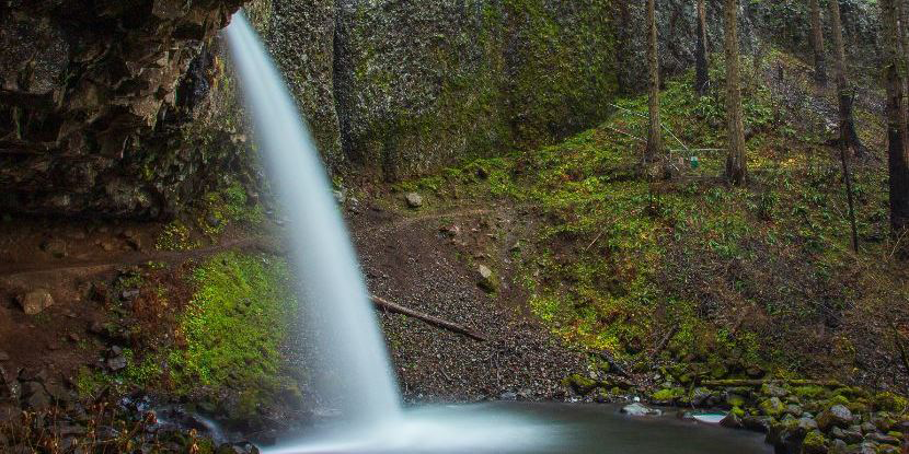
- In 0.4 mile, come to Ponytail Falls, where the trail passes behind the 88-foot falls in a naturally eroded cavern, offering fantastic photo opportunities.
- Please always stay on the trail and clean your boots before and after you hike. Hikers are a common vector for spreading invasive seeds.
- There are no restrooms at the trailhead.
Friends of the Columbia Gorge does not track trail closures. If you are planning a hike in the Gorge, please check other sources in advance for the latest updates, including the U.S Forest Service, Ready Set GOrge, and AllTrails. Recreational activities in the Gorge can involve risk of injury, death, property damage, and other dangers. Friends does not assume responsibility for any such outcome resulting from the use of the information on our hiking web pages. Your use of these web pages is strictly at your own risk.
Post-Hike Explorations
Combine this hike with more waterfalls and views on two hikes that start 3.6 miles to the east. From Horsetail Falls, drive east on the Historic Highway. At the on-ramp to I-84 east, veer right onto Frontage Road (an old highway remnant). Just before it re-enters I-84, turn right into the John B. Yeon trailhead parking area. Trails here lead to Elowah Falls and Upper McCord Creek Falls, both short hikes with waterfalls and views.
Directions & Travel Tips
Eastbound I-84: Take exit 28/Bridal Veil. At the top of Bridal Veil Road, turn left on the Historic Columbia River Highway and drive 5.6 miles to the parking area at Horsetail Falls.
Westbound I-84: Take exit 35/Ainsworth and drive 1.6 miles west on the Historic Highway to the parking area at Horsetail Falls. There are no restrooms at the trailhead.