On the Trail
This easy, 3.4-mile, out-and-back hike along beautiful Falls Creek leads to one of southern Washington’s highest waterfalls, 335-foot Falls Creek Falls. The hike gains 750 feet in elevation.
Permits & Pets
This area is in the Gifford Pinchot National Forest. No permits are required. Dogs can be off leash.
Trail Notes
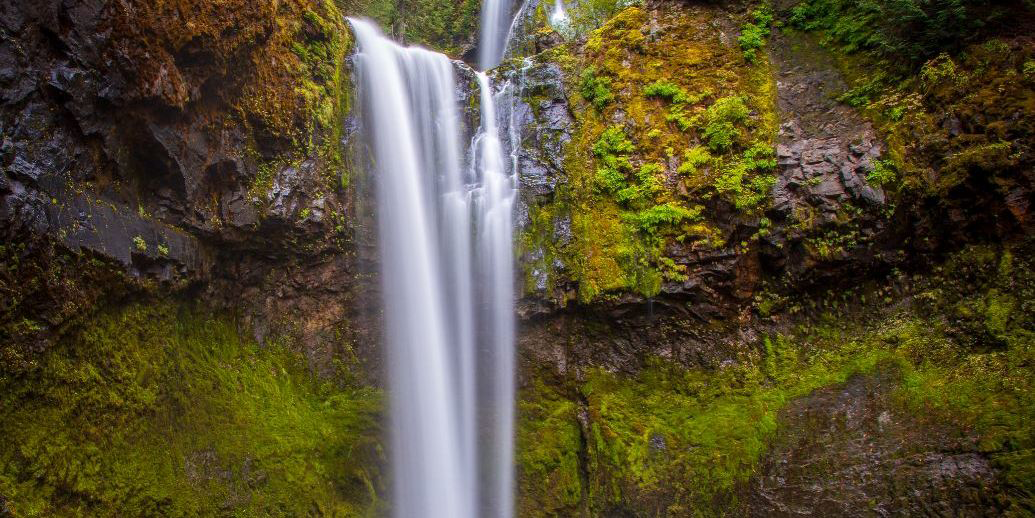
- From the trailhead, Trail 152A follows Falls Creek 1.7 miles to the waterfall. Along the way, a cable suspension bridge spans a rock gorge, giving spectacular views of the creek’s whitewater. Continue uphill, crossing a creek to the base of the waterfall. It drops in three tiers: a 109-foot fan, then a 135-foot drop across several segments, which come together for a final 91-foot drop into a narrow amphitheater gorge. At high-water levels, prepare to get sprayed at the base of the falls.
- Return via the same route.
- Please always stay on the trail and clean your boots before and after you hike. Hikers and their dogs are common vectors for spreading invasive seeds.
- A restroom is at the trailhead.
Friends of the Columbia Gorge does not track trail closures. If you are planning a hike in the Gorge, please check other sources in advance for the latest updates, including the U.S Forest Service, Ready Set GOrge, and AllTrails. Recreational activities in the Gorge can involve risk of injury, death, property damage, and other dangers. Friends does not assume responsibility for any such outcome resulting from the use of the information on our hiking web pages. Your use of these web pages is strictly at your own risk.
Post-Hike Explorations
At the Government Mineral Springs Road fork you passed on the way in, turn onto this road to explore a grove of old-growth cedar and Douglas fir, a mineral spring, and a historical recreation site. From 1910 until it burned down in 1935, a large hotel stood here, where people drank the mineral water. Nearby, a one-way loop road encircles a former campground in a beautiful grove of old-growth trees. The campground operated from the early 1900s to the 1970s.
In 1937, the Civilian Conservation Corps built a guard station cabin here at the campground. It has been renovated and can be rented out at recreation.gov. If a vehicle is parked near the cabin, someone has rented it for the evening; do not explore immediately around it.
In the 1970s, after several trees fell, the campground was closed, and moved to an area just beyond the old-growth grove. The pump to “Iron Mike,” the mineral springs, is near the new campground. It’s a soda springs, with a large amount of dissolved sodium salts, mostly sodium bicarbonate. It’s naturally CO2-charged. Drinkable, yes; palatable, no.
Directions & Travel Tips
From SR 14 at the Bridge of the Gods (tolls are required on the bridge), drive 5.9 miles east on SR 14 to Wind River Road. Turn left; in 8.5 miles pass through the community of Stabler. Drive another 5.7 miles and come to a Y intersection; Government Mineral Springs Road is the left fork. Take the right fork, Wind River Road/NF 30, drive 0.7 mile to NF 3062, and turn right.
The route from the start of NF 3062 to the trailhead is 2.4 miles, as follows: On 3062, keep left on 3062 where NF 055 comes in on the right; keep left on 3062 where NF 056 comes in on the right. In another 0.9 mile, turn right on FR 057, which leads to the trailhead parking area.
Note: The road to the trailhead is gated December 1 to March 31 at a point 2 miles before the parking area. During those months, park near the gate and walk the road 2 miles, adding a total of 4 miles to the hike.