On the Trail
This 1.9-mile loop is an easy, family-friendly hike, gaining only 200 feet in elevation. No place in the Columbia Gorge offers the spring wildflower diversity and duration of Catherine Creek. For that it is justly popular. Once a cattle ranch, this spectacular site was the first land purchase made by the U.S. Forest Service after the Columbia Gorge became a protected National Scenic Area in 1986.
Permits & Pets
The area is administered by the U.S. Forest Service. No passes are required. Dogs are required to be leashed at all times.
Trail Notes
- From the trailhead on the north side of Old Highway 8, head northeast on the closed road marked “FR 020” as it drops to Catherine Creek. The road continues upstream to a junction with another closed road, marked “FR 021,” aka the Catherine Creek Arch Trail. Follow this trail-road as it crosses the creek on a bridge and heads upstream along its east side, next to a columnar basalt wall.
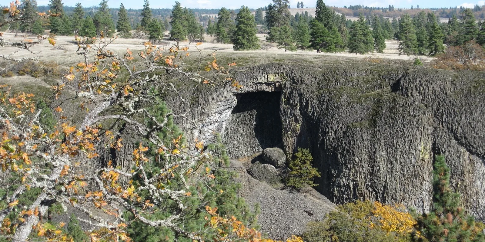
- Pass an abandoned corral. Above it is the trail’s eponymous rock arch, atop a talus slope. The arch is significant to Native Americans and is fenced off to discourage hikers from exploring the area. From here, the trail winds through Oregon white oak and meadows. Come to a collapsed building. Like the corral, it dates from the land’s days as the Lauterbach Ranch.
- The trail-road leaves the valley and passes the Catherine Creek Arch-Catherine Creek Pinnacles Trail junction. Here, veer right in a ponderosa pine/oak parkland. Under power lines, reach a signpost at the Catherine Creek Arch-Eastside Trail junction, and go right.
- This often-boggy section rises to the western slopes of Tracy Hill through seeps and patches of April-blooming camas. The path steers down the basalt rim of Catherine Creek’s small canyon, passing a section of rock that is peeling off, but offers a great viewpoint. Pass the fenced-off arch. The fence precludes a good look at it, but from the end of the fence, step over to the rim for a view down to the old corral and Catherine Creek itself. Southward is a great view of Mount Hood. On this rocky rim bloom spectacular bitterroot in May. Continue hiking down the open scabland slope, stepping in and out of a narrow gully that funnels a rushing creek. Keep descending to Old Highway 8, turn right, and walk about 0.25 mile back to the start. Keep an eye (and ear) open for cars. Pass over Catherine Creek on a bridge, shortly before the parking area.
- Please always stay on the trail and clean your boots before and after you hike. Hikers and their dogs are common vectors for spreading invasive seeds.
- A portable toilet is at the trailhead.
Post-Hike Explorations
Six miles west on SR 14, find a variety of eats, and local spirits and beers, in Bingen. Founded in 1892, the town is named for Bingen am Rhein in Germany. Unlike its namesake, this town’s name is pronounced “Bin-jin,” not “Bing-en.” Bingen is one of two Gorge towns (Wishram is the other) at which Amtrak passenger trains stop on their way from Portland to Chicago.
Other Hikes from This Trailhead
Catherine Creek Universal Access Loop
Directions & Travel Tips
Directions & Travel Tips
From the Hood River Bridge (toll required to cross), drive SR 14 east for 5.8 miles and turn left onto Old Highway 8. Drive 1.5 miles to the gravel parking areas on both sides of the road.