On the Trail
This mostly flat 2.5-mile loop is within Rooster Rock State Park, an 873-acre park along the Columbia River. Please note: All of the area east of the parking lot, along the river, is one of Oregon’s two clothing-optional beaches, which this trail hikes near.
Permits & Pets
Rooster Rock State Park is managed by Oregon State Parks. An Oregon State Parks Pass is required. Dogs must be on leash.
Trail Notes
- The trailhead for this hike is in the southeast corner of the park’s vast parking lot. (It’s not the trail near the restrooms.) The trail begins in a grassy area and loops through a bench above the river, passing through forests of maple and oak, and open meadows. Informal trails here are braided together, but keep east, above the drop-off to the bottomlands on the left.
- After about 3/4 mile, the path drops down and joins the water-level path. Continue east through a grassy meadow for about another 1/4 mile to the Sand Island Viewpoint. From here, you can look across a narrow channel of the Columbia River to Sand Island. Wildlife is common here, including many kinds of migratory waterfowl, herons, bald eagles, deer, and even sea lions.
- Follow the fading path farther east along the shore for another 1/4 mile or so. There are also great views to the east, including Angel’s Rest, Hamilton Mountain, and the canyon walls of the Gorge.
- At a crumbling, sandy bank, head up the hill to the right, which leads to a large meadow. I-84 is visible and audible. Find a faint path leading up the hill to the west. As you climb, views over your shoulder get better and better.
- At the top of the hill, look east up the Gorge. The top of Beacon Rock can be seen peeking over a ridge on the Washington side. The trail ends near the entrance road. From here, turn right and walk back through the parking area to the trailhead.
- If you choose to complete the loop, continue west along the ridge crest. The trail works its way up and down, passing several large, fern-laden maples along the way. This is a mostly deciduous forest, and in the winter it’s pretty open with views down the hill to the freeway. At one point you’ll be within a few feet of a paralleling trail, but stay on the trail you’ve been following a bit farther. There’s a section of forest near the highest point that is completely carpeted in horsetails so thick the ground seems to have vanished.
- The trail through this section is very well maintained and looks like a very narrow road. When you come to an obvious trail fork on the side of a hill, go uphill to the right. At the crest is a concrete disc golf tee and you can look down the hill at the basket. From the tee, head west (left) on the main trail and soon you’ll be back at your car.
- You can add another 2 or more miles to this loop by heading west. Walk through the picnic area and past the fee booth. Head across an expansive lawn with group picnic areas, another disc golf course, and tall, yellowing cottonwoods. Pick up a grassy track before Group Picnic Area D and pass restrooms on the right.
- Reach the small marina. An outlet from Mirror Lake runs under the freeway to here, and there are views up to Crown Point.
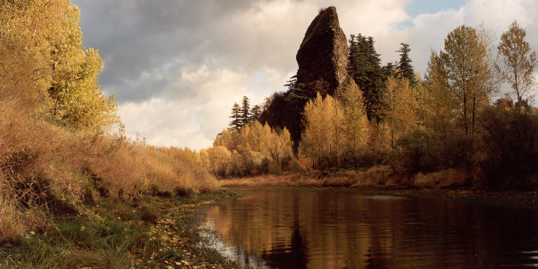
- Head right to the end of the road at the Car Top Water Vehicle Parking Area. Take up a gravel trail that leads through blackberries, cottonwoods, false indigo, and willow on a breakwater separating the river from a channel leading to the marina. Rooster Rock, 175 feet high, looms above all the way. The trail drops to the muddy shoreline of the channel; you will probably have to turn back here.
- Please always stay on the trail and clean your boots before and after you hike. Hikers are a common vector for spreading invasive seeds.
- A restroom is near the trailhead.
Friends of the Columbia Gorge does not track trail closures. If you are planning a hike in the Gorge, please check other sources in advance for the latest updates, including the U.S Forest Service, Ready Set GOrge, and AllTrails. Recreational activities in the Gorge can involve risk of injury, death, property damage, and other dangers. Friends does not assume responsibility for any such outcome resulting from the use of the information on our hiking web pages. Your use of these web pages is strictly at your own risk.
Post-Hike Explorations
Visit the eponymous rock, a basalt pillar that was part of a landslide mass that slid from the cliffs above. It’s at the park’s far west end, near the boat ramp. Reach it by walking or driving west on the main park road to its end. A cannery once operated near Rooster Rock; its pilings are still visible. Passenger trains once stopped here.
Find the best beaches by taking the trail near the restroom at the far east end of the park. It leads to cottonwood forests in bottomlands along the river, and out to beaches. At low water, wade or walk dry sand over to Swan Island. All of the area east of the parking lot, along the river, is one of Oregon’s two clothing-optional beaches.
Directions & Travel Tips
Rooster Rock State Park: On I-84, take exit 25 to Rooster Rock State Park. A restroom is near the trailhead. There is a $5 day use fee.