On the Trail
This easy, 1.5-mile, out-and-back trail is the newest trail in Beacon Rock State Park, completed in 2014. It gains about 272 feet and links to the trail to the summit of Beacon Rock, as well as the riverfront Doetsch Ranch loop, a paved, 1-mile walk.
Permits & Pets
A Discover Pass is required at this Washington State Park. Purchase one online or on-site. Dogs must be on leash at all times.
Trail Notes
- Note: This trail travels through a brushy area along Riddell Lake, with blackberries and nettles at times overhanging the trail.
- From the parking area, walk to Woodard Creek and turn left onto Moorage Road, which passes under railroad tracks. The signed trailhead is on the right side of this road, just past the railroad tracks.
- Cross the creek on a footbridge that’s removable during high water, then ascend a few switchbacks, after which the trail levels and gradually climbs northward. It passes through a forest of Douglas fir and alder with a lush understory of vine maple, huckleberry, and ferns. An abandoned filbert orchard hints at the land’s former life.
- At 0.1 mile from the trailhead, come to the mossy remains of a small brick building of unknown origin — a storage building, perhaps, to hold dynamite used by the Army Corps of Engineers for nearby projects. Across the trail is a walnut tree. Like the filberts, it was planted by an early inhabitant of the land.
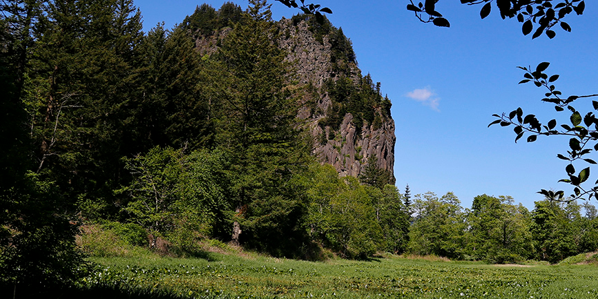
- In another 0.1 mile, come to an unmarked trail junction. Marshy, seasonal Riddell Lake can be seen through the trees. The right fork skirts the lake’s east side; the left circles its west side. Go left and enjoy views of Beacon Rock through the trees.
- Riddell Lake was the site of a summer home for the family of H. H. Riddell, a lawyer who practiced in The Dalles and Portland. He was postmaster for The Dalles and worked in the 1920s with the Department of Public Health in efforts to eliminate mosquitoes in Portland and the Gorge. He was also co-founder of Oregon Light and Power, Portland’s first electric utility. Nothing remains of the Riddell home.
- In 0.2 mile, the trails around the lake rejoin at its north end. Continue past power lines, ascending slightly, then descend to reach the northern trailhead to this hike on SR 14. To ascend Beacon Rock, turn right, which leads to the Beacon Rock trailhead (and restrooms, at the far end of the parking area).
- To return to the start, retrace your steps.
- Please always stay on the trail and clean your boots before and after you hike. Hikers are a common vector for spreading invasive seeds.
- Restrooms are located near the park’s boat launch.
Friends of the Columbia Gorge does not track trail closures. If you are planning a hike in the Gorge, please check other sources in advance for the latest updates, including the U.S Forest Service, Ready Set GOrge, and AllTrails. Recreational activities in the Gorge can involve risk of injury, death, property damage, and other dangers. Friends does not assume responsibility for any such outcome resulting from the use of the information on our hiking web pages. Your use of these web pages is strictly at your own risk.
Post-Hike Explorations
After crossing the removable bridge over Woodard Creek, turn left to explore the park’s boat launch. From the floating dock, enjoy a fantastic view of Beacon Rock’s south face, sheared vertical by the Ice Age Floods. Across the channel is Pierce Island, a natural area preserved and owned by Columbia Land Trust.
From the boat ramp, walk back west on the road and cross over Woodard Creek. This 5.5-mile-long creek runs almost entirely through public lands, through the Gifford Pinchot National Forest and Beacon Rock State Park. It is home to native chinook and steelhead runs. In an early 2010s restoration project, logjams and other structures were placed in the creek to reduce depth, create riffles and pools, and otherwise reconstruct a more natural fish-friendly habitat for both returning salmon and juvenile fish.
Just past the creek, turn left onto the 1-mile paved trail at the park’s day use area. The trail loops through meadows that were cattle pastures from 1920 to 1987. Interpretive signs describe the Ice Age Floods, Lewis and Clark’s passage through here, and other elements of local history.
Other hikes at or near this trailhead (link to trail pages)
Directions & Travel Tips
On SR 14 near milepost 34, turn toward the river onto Doetsch Ranch Road, part of Beacon Rock State Park. Drive 0.4 mile, passing the parking area for a day use area on the right, another large parking area just before the road crosses Woodard Creek. Park here. Restrooms are farther on this dead-end road, at the park’s boat launch.
Car-Free Travel
A seasonal weekend shuttle stops at this trailhead. View schedule and fare information.