On the Trail
The Lyle Cherry Orchard Preserve is closed indefinitely due to the Lyle Hill Fire. For your safety, please stay out of the area and do not visit or hike the trails.
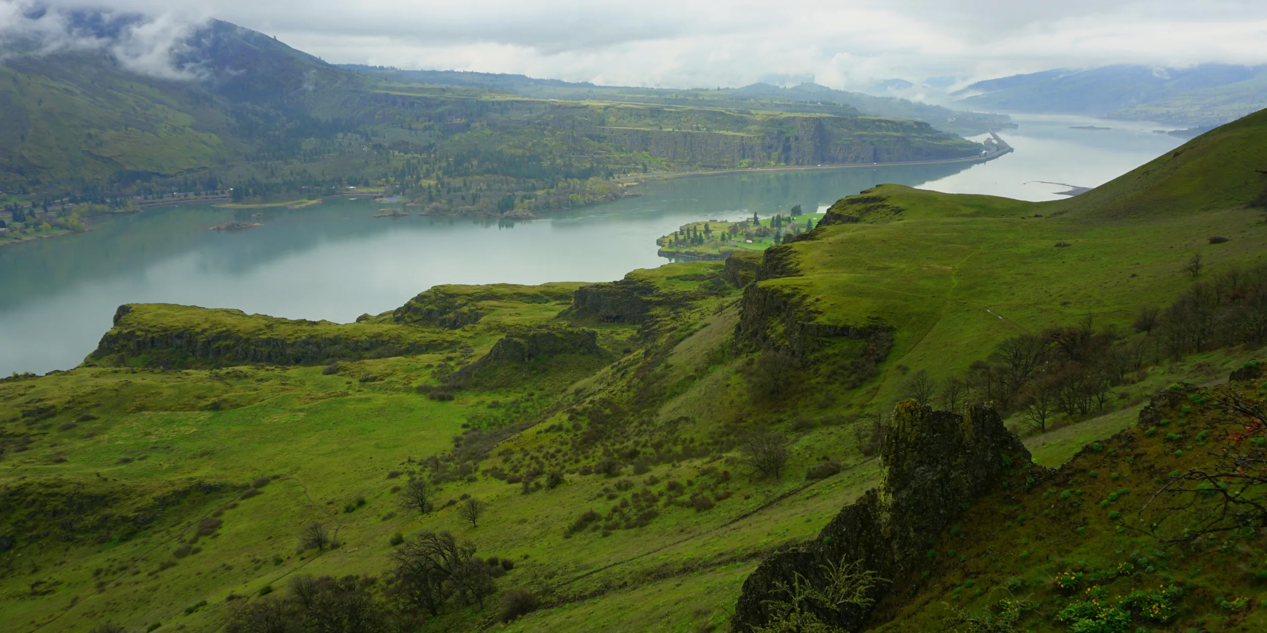
This variable-distance, mostly out-and-back trail hike (it’s 6.5 miles if you include the Cherry and Lyle loops added from 2019-21) gains 1,100 feet in elevation. With its southern exposure and rocky terrain, the hike offers a succession of wildflower blooms from February through May. The bloom generally peaks in mid-to-late April. The trail is midway along the Rowena Gap, where the Columbia cut through folded layers of basalts. The result is a spectacular scene of multiple basalt flows shorn into 1,000-foot-high cliffs.
Approximate trail distances, provided by Washington Trails Association:
- Lyle Cherry Orchard plus Cherry Loop and back: 5 miles
- Lyle Cherry Orchard to Lyle Loop and back: 4 miles
- Lyle Cherry Orchard to both loops and back: 6.5 miles
Nesting falcon advisory: A sign at the intersection near the viewpoint on the Cherry Loop alerts visitors to nearby falcon nests. Nesting birds are easily disturbed by your presence. Disturbance can cause them to fly off the nest, which can result in stress or even death of young falcons. Please be quiet and stay on the trail.
Permits & Pets
Lyle Cherry Orchard is a preserve owned by Friends of the Columbia Gorge Land Trust. No permits are required. We recommend always keeping your dog leashed to protect the sensitive landscape and respect other hikers. The trail also cuts across steep hillsides that drop to cliffs below. The seasonal presence of rattlesnakes and the yearlong presence of ticks also offer good reasons to use a leash. Motorized vehicles, horses, and bicycles are prohibited on the trail, as well as smoking, hunting, and fires.
Trail Notes
- From the parking area, the trail begins next to a tall rock pillar, and immediately begins climbing through scrub oaks. Poison oak frequently borders the trail here and elsewhere on the hike.
- In about 0.1 mile, the trail intersects the Lyle Convict Road, a would-be north bank highway started in 1910 (and abandoned in 1911), built by imprisoned men whose work camp was just west of here. The road was the idea of Sam Hill, whose vast properties in nearby Maryhill warrant a day’s worth of investigations. Hill’s futile efforts to persuade the Washington legislature to fund a river road running east from Vancouver resulted in his attention turning towards Oregon. There, his vision found more fertile ground. The result is the Historic Columbia River Highway.
- At a wooden trailhead sign for the Cherry Orchard, detour left a bit to investigate the Convict Road as it winds westward a short way before being cut off by rock slides. Houses on the waterfront across the river, are on Rowena River Road, sandwiched between two areas of Mayer State Park. Rowena Crest is west of the park.
- From the Convict Road, come back to the trailhead sign. Clean your boots on the boot brush, to avoid bringing invasive weed seeds onto the property. Since 2015, volunteers and land trust staff have been working to eradicate invasive yellow starthistle here.
- On the main trail, keep climbing. Notice the round river pebbles on the trail. They were deposited by the Missoula Floods. As water repeatedly breached glacial ice dams in western Montana 12,000 to 17,000 years ago, glacial outburst floods resulted. These walls of water roared westward along the route of the Columbia River, scouring hillsides into cliffs. At this point in the river, the Rowena Gap, the narrower channel created a hydraulic dam at which floodwaters backed up, reaching 1,000 feet deep.
- In about 0.8 mile, a wide, level bench extends west of the trail. For interesting views of Lyle, its football field, neighborhoods, and riverfront, follow a side trail across this bench to its west end.
- On the new Cherry Loop to the east, check out the viewpoint providing beautiful river views. The trail’s summit is about 1.3 miles from the start. From there, continue on a gentler grade through oak woodlands. Continue up a steep climb involving switchbacks and pass a seasonal pond. You’ll reach a dirt road at about the 2.4-mile mark. Turn right, but before you do, clean your boots again on the boot brush to prevent yellow starthistle from hitch-hiking a ride into the Lyle Cherry Orchard, which is just ahead. The surviving, gnarled cherry trees are at the far end of the wide, grassy area. Note: This area is considerably steeper than the rest of the trail and may be considered strenuous by some.
- On the new Lyle Loop to the north and west, you will cross the plateau and then switch back up the ridge through a Garry Oak grove and past wildflowers. This route is best hiked counterclockwise. Sticking to this direction reduces congestion and the need to pass people on the trail that can be narrow where it runs along steep slopes above the town of Lyle.
- Please always stay on the trail and clean your boots before and after you hike. Hikers and their dogs are common vectors for spreading invasive seeds.
History
Friends’ founder Nancy Russell (1932-2008) was drawn to the extreme beauty of this site. Before Gorge land use protections were put in place, she purchased several parcels of land that today comprise most of the 540-acre Lyle Cherry Orchard preserve. She named the site for the orchard remnant at the hike’s easternmost point. Had she not bought the parcels, they would likely have been developed into view home sites. In a 2005 video, Nancy Russell talks about why she purchased the land. Her comments about the orchard are at the 8:53 minute mark.
In 2009, the Estate of Nancy Russell bequeathed the Cherry Orchard property to Friends of the Columbia Gorge Land Trust. The trust leads work parties of volunteers to remove invasive species, enhance trails, and remove old structures. In 2013, a dilapidated house and outbuildings were removed from the grassy area near the old orchard. In 2015 and in 2018, volunteers removed more than 1,700 feet of fencing.
From 2018-2019, the Washington Trails Association (WTA) constructed the new Cherry Loop on the existing trail, creating an additional .8 miles of new trail and rerouting problematic sections. In 2020, WTA began construction on the new Lyle Loop, which will add an additional 2 miles to the Lyle Cherry Orchard trail system.
Friends of the Columbia Gorge does not track trail closures. If you are planning a hike in the Gorge, please check other sources in advance for the latest updates, including the U.S Forest Service, Ready Set GOrge, and AllTrails. Recreational activities in the Gorge can involve risk of injury, death, property damage, and other dangers. Friends does not assume responsibility for any such outcome resulting from the use of the information on our hiking web pages. Your use of these web pages is strictly at your own risk.
Post-Hike Explorations
Learn more about the Lyle Convict Road and the camp where the convicts lived at the Twin Bridges Museum in Lyle. It is opened June to September on Saturdays, noon to 5 p.m., or by appointment. See Sam Hill’s experimental Maryhill Loops Road, where he tried various paving techniques. The road begins about 25 miles east of the trailhead, off SR 14.
Note: The Google map for this trail (below) does not yet show the additions of the Lyle and Cherry Loops. Click here to view a map that shows the Cherry Loop; a new map including the Lyle Loop will be posted soon.
Directions & Travel Tips
From the Hood River Bridge ($2 bridge toll), drive east on SR 14 for 11 miles to Lyle. Continue on SR 14 through two tunnels, about one mile east of town. Immediately past the second tunnel, pull into the wide gravel area on the left (north) side of the highway.