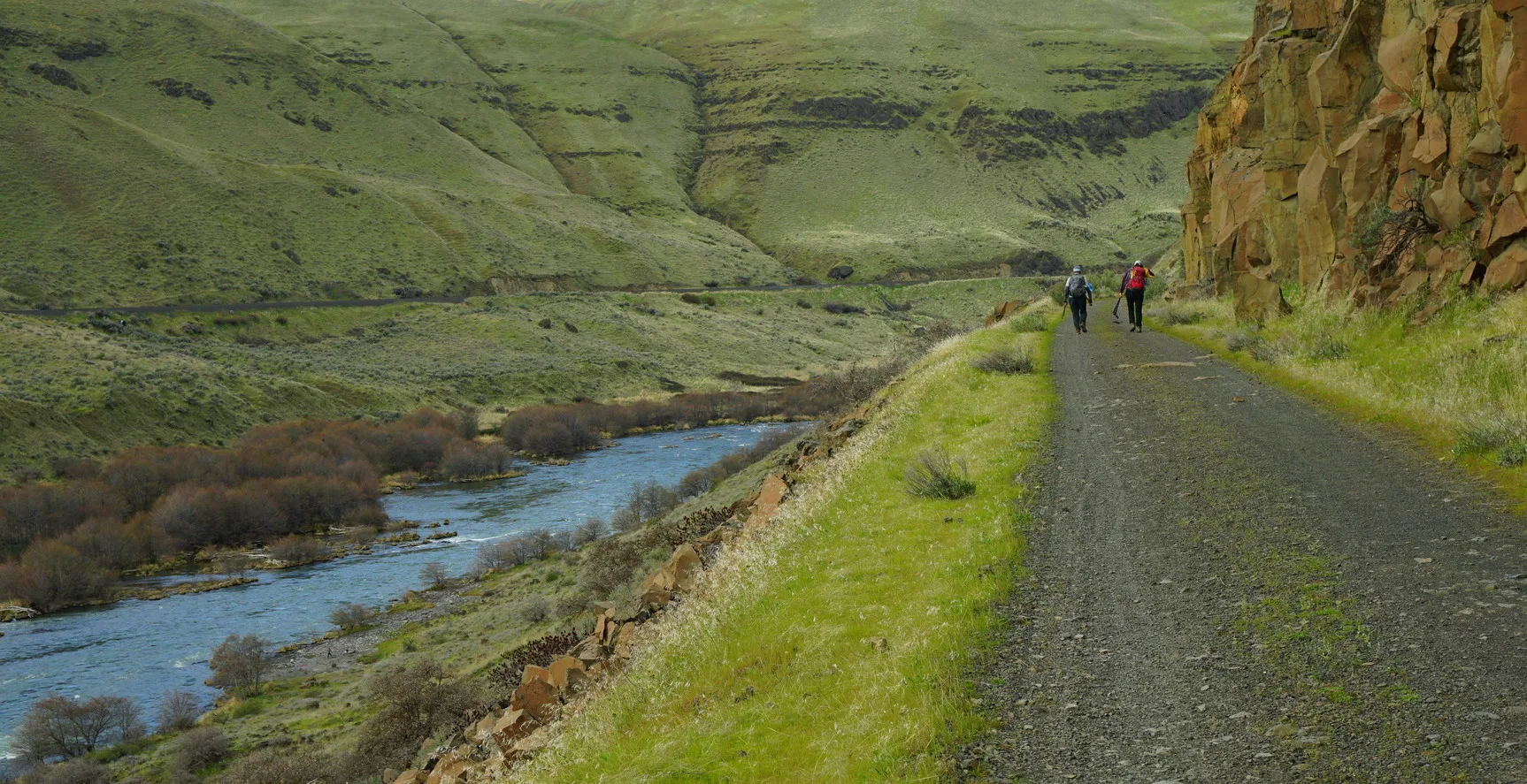
On the Trail
This nearly flat hike travels 11.3 miles along the east bank of the Deschutes River on a former railroad grade. Walk all or part and return along the same route. In late winter and early spring, this trail offers warmth and wildflowers, spectacular rocky cliffs, views of rapids, and railroad and farm vestigia. Ride mountain bikes and take short hikes at various intriguing points along the way.
Permits & Pets
This area is managed by Oregon State Parks. An Oregon State Parks Pass is required and can be purchased on-site with $5 cash. Dogs are required to be leashed at all times.
Trail Notes
- From the parking area, hike uphill 0.1 mile on a narrow trail to the wide Deschutes River Trail, a former railway alignment, and turn right. The trail’s first 2 miles are within the Deschutes River State Recreation Area. After that, the trail is within Oregon Department of Fish and Wildlife Lands and Bureau of Land Management lands. You can also hike upriver for a while along either the Riverview Trail or Blackberry Trail. They parallel the River Trail on the slopes below, closer to the river.
- About 1 mile from Rattlesnake Bend, the trail arrives at Gordon Canyon. Trains used to travel on a high trestle here, but it no longer exists. Descend on a vehicle track to cross Gordon Creek and then head back up to the railroad grade. Down below, the Colorado Camp outhouse and a grassy expanse are worth investigating. Back on the railroad grade, pass below Gordon Cliffs, lichen-stained basalt formations, some in beautiful radiating circles.
- Across the river is the Oregon Trunk Railroad (operated by BNSF Railway) on the steep west bank. On both sides of the river, mostly out of sight, are agricultural lands. Pass above another outhouse at Gordon Ridge Camp.
- At 5.6 miles, come to a well-preserved railroad car with an intact wooden floor. Go inside for lunch and a break from the sun. A trail leads to the river here.
- At 6.6 miles are the remains of Free Bridge. Unlike private toll bridges crossing the river, this bridge was constructed by Wasco County in 1887 (and rebuilt in 1905) to offer free passage. However, the bridge was apparently dynamited by the opposition in 1914. A footing on the east side and another in the middle of the river are visible. Before passing above the bridge supports, look for a post that once held an interpretive sign with a photo of the bridge. Here the narrow Free Bridge Road can be seen descending the slope on the canyon’s west side; also visible is a road ramp to the left of the pillars on the east side.
- Past Free Bridge are Washout Rapids at a river bend. Pass through a rubble-strewn cutting in the basalt.
- At 7.8 miles, an old trestle ramp on the right spanned a shallow creek until 2015, when it was dismantled. Below is another outhouse at Bedsprings Camp. Across the river, picturesque buttresses fortify the steep slopes above the rail line. Continue around another bend and, about 1 mile farther, pass a rusting piece of farm equipment on the left. Soon, cross a cattle grid that marks private land. Stay on the trail here, between the grids.
- At 10.1 miles, a trail leads down to Fall Canyon Camp, a good spot to camp if you’re backpacking.
- In 0.75 mile beyond the camp are picturesque remains of the Harris Homestead. Beyond the house are corrals, cattle chutes, sheep shearing stalls, and open sheds with some farm equipment. Continuing down the road, pass through an allee of hackberry trees, and reach a grove of ponderosa pines with a refurbished caboose that was a residence for seasonal farmworkers. There’s also a shed and paddock as well as an outhouse and small pump house. Across a channel of the Deschutes is Harris Island. A little farther on, at the mouth of Harris Canyon, arrive at the recently restored Harris Canyon Water Tower, at 11.3 miles.
- Return the way you came.
- Please always stay on the trail and clean your boots before and after you hike. Hikers and their dogs are common vectors for spreading invasive seeds.
- Restrooms are located at the campground.
History
The railroad line here exemplifies the “railroad wars” common during the development of the western United States. The Deschutes Railroad Company (Union Pacific) began surveys on the east bank of the river in 1906. Almost immediately after this, employees of the Oregon Trunk Railroad, incorporated in Nevada, surveyed the west bank and began construction. Construction crews snuck into each other’s supplies and sabotaged them, and there were incidents where one side dynamited the other’s equipment. Gradually, however, the competing railroads realized the situation was economically untenable, and the Deschutes Railroad began using sections of the Oregon Trunk line. The Deschutes finally abandoned its entire route along the east bank in 1936.
Friends of the Columbia Gorge does not track trail closures. If you are planning a hike in the Gorge, please check other sources in advance for the latest updates, including the U.S Forest Service, Ready Set GOrge, and AllTrails. Recreational activities in the Gorge can involve risk of injury, death, property damage, and other dangers. Friends does not assume responsibility for any such outcome resulting from the use of the information on our hiking web pages. Your use of these web pages is strictly at your own risk.
Post-Hike Explorations
Visit Celilo Park on the Columbia River (3.3 miles west on Hwy 206, or I-84 exit 97). Swimming is excellent from the park’s gravel shoreline on hot days.
Celilo Park was built by the Army Corps of Engineers after the original site of Celilo, a Native American village, was inundated by The Dalles Dam in 1957. Upstream was Celilo Falls. Downstream is Celilo Bridge, aka the Oregon Trunk Rail Bridge. When it was built in 1912, all of its piers were on dry rock at low water. Across the river is Wishram, Washington, a newer iteration of another Native American village. Wishram also is significant for its location at the junction of north-south and east-west rail lines. Its rail heritage continues today: Amtrak passenger trains, on their run from Portland to Chicago, stop at this tiny village.
East of the current park is a treaty access fishing site, for the exclusive use of Indian fishers from members of the four Columbia River Inter-Tribal Fish Council tribes. Like other such sites in the Gorge, the land was set aside by Congress to provide fishing locations to Indian fishers whose traditional fishing grounds were inundated behind Columbia River dams.
The Confluence Project plans an art installation at the park, a bookend to its “Bird Blind” installation at the opposite end of the Gorge, at the Sandy River Delta. Famed artist Maya Lin has designed a 500-foot elevated walkway for Celilo Park inspired by indigenous fishing platforms along the Columbia. The work will be done in conjunction with the Yakama, Nez Perce, Umatilla, and Warm Springs tribes.
Other Hike at This Trailhead
Directions & Travel Tips
From I-84 eastbound: Take exit 97 for OR-206 to Deschutes/State Park/Celilo. Turn right, and cross the railroad tracks. At Highway 206, turn left and drive 3 miles, crossing the Deschutes River. Immediately after, turn right into the recreation area.
From I-84 westbound: Take exit 104/U.S. 97. Turn left on U.S. 97 and right onto the second cross street, Highway 206. Drive 4.4 miles. Immediately before crossing the Deschutes River, turn left into the recreation area.
From the entrance, drive 0.4 mile, passing the campground, to the southernmost paved parking area.