On the Trail
This easy, 0.2-mile walk showcases a beautiful, arched bridge from 1914, the second bridge built along the Historic Columbia River Highway, and a scenic waterfall at Shepperd’s Dell on Young Creek.
Permits & Pets
Shepperd’s Dell State Natural Area is managed by Oregon State Parks. No permits are required. Dogs must be on leash.
Trail Notes
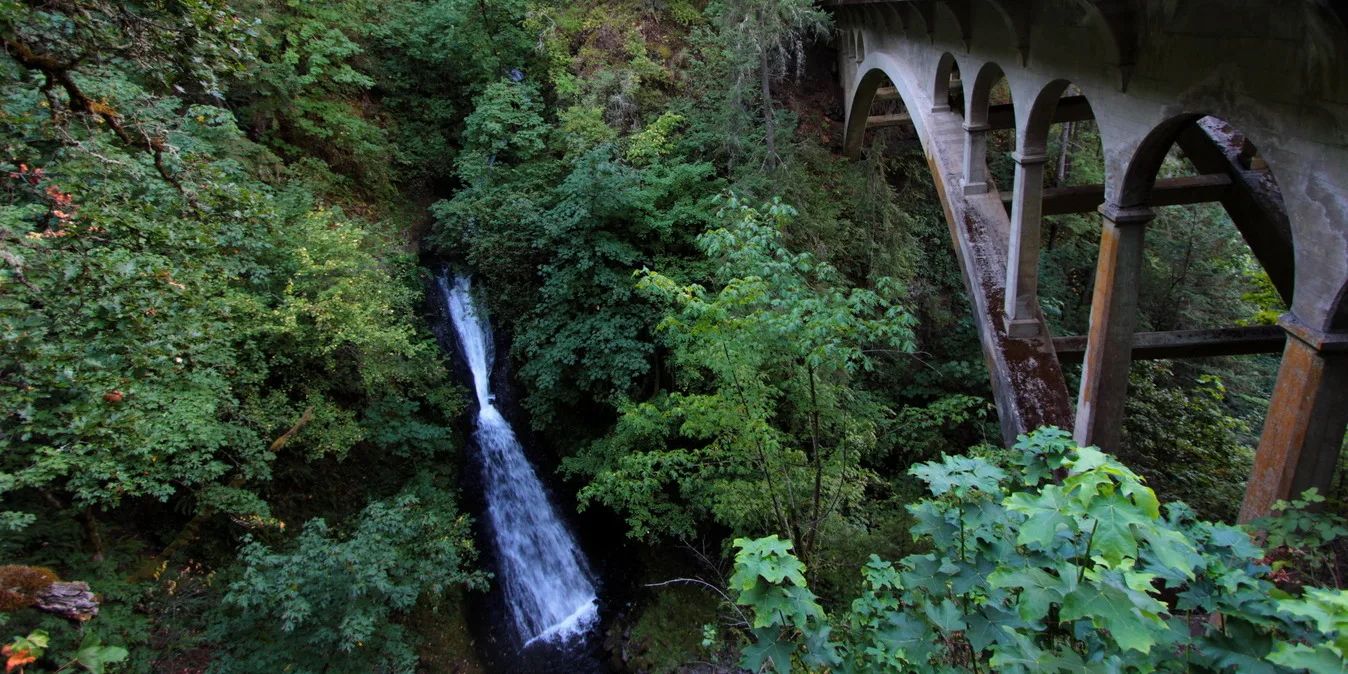
- Find the paved trail to the falls on the east end of the bridge over Young Creek. The trail was cut into the basalt cliffs at the time the Historic Highway was constructed.
- The total height of Shepperd’s Dell Falls is 220 feet, but upper tiers cannot easily be seen. What can be seen is the 45-foot drop of the hourglass-shaped falls above the bridge, and two 20-foot drops below the bridge.
- Along with other Columbia River Highway bridges between Troutdale and Eagle Creek, Shepperd’s Dell Bridge was designed by state bridge engineer K.P. Billner in 1914. It spans the 100-foot-wide canyon with a series of arches below its deck, beautifully complementing the adjacent falls.
- Later highway bridges, most notably Mosier Creek and Dry Canyon Creek, were designed by the more famous Conde B. McCullough, who was influenced by this bridge’s elegant design. The Oregon Bridges Recording Project describes the bridge as having “a deck arch design with a unique solid curtain wall above the center of the arch.”
- Please always stay on the trail and clean your boots before and after you hike. Hikers are a common vector for spreading invasive seeds.
- There is no restroom at the trailhead.
Friends of the Columbia Gorge does not track trail closures. If you are planning a hike in the Gorge, please check other sources in advance for the latest updates, including the U.S Forest Service, Ready Set GOrge, and AllTrails. Recreational activities in the Gorge can involve risk of injury, death, property damage, and other dangers. Friends does not assume responsibility for any such outcome resulting from the use of the information on our hiking web pages. Your use of these web pages is strictly at your own risk.
Post-Hike Explorations
Visit Bridal Veil Cemetery, where George Shepperd’s beloved second wife is buried, along with other early settlers. To get there, drive east on the Historic Highway to the intersection of Bridal Veil Road. Just east of it, find an older version of Bridal Veil Road. Turn left (north) on it and drive to the cemetery, on the right. Visit the now-closed Bridal Veil Post Office, which was the last bit of commerce in a once-thriving timber town. It was a popular place to batch-mail wedding invitations. The post office is at the lower end of Bridal Veil Road, just above I-84.
Directions & Travel Tips
Shepperds Dell Trailhead: Eastbound I-84, take exit 28/Bridal Veil and drive uphill on Bridal Veil Road; at the top, turn right (west) on the Historic Highway. Travel 1.6 miles to Shepperd’s Dell. Westbound I-84, take exit 35/Ainsworth, and drive 8.9 miles west on the Historic Highway.