This challenging trail has it all: waterfalls, cliffs, deep forests and stunning views of the Gorge. The trail begins with a moderate climb, going through second-growth Douglas Firs, then under power lines. There are nice views of Hamilton Mountain and Bonneville Dam from a bench about 0.4 miles in. There is also a trail leading to an alternate trailhead in the campground.
About a mile from the trailhead, you’ll come to the waterfall area. There is only one creek here, but there are three named waterfalls. First, you can take a side trail to the right for a limited view of Hardy Falls, the lowest of the waterfalls. Hardy Creek pours into the Pool of Winds from the right, tumbling 50 feet before hitting the pool in the rocks. Back on the main trail, continue a few hundred yards and go left on a side trail that ends at a railed lookout to a view of the two upper falls, Pool of the Winds, and Rodney Falls. Then the water cascades out along a streambed and slides down a waterslide-like channel until it hits a rocky labyrinth. Return to the main trail and switchback down to a sturdy footbridge below the falls for more cooling spray and photo opportunities.
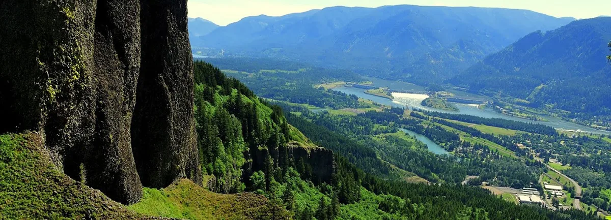
Beyond the Hardy Creek Bridge, switchback uphill and climb 0.2 mile to a junction with the Hardy Creek Trail. In the warmer seasons, your trail may be lined with ferns, Oregon grape, thimbleberries and wild rose. In fall, this area is filled with an understory of yellow maples beneath the green firs. Take the “more difficult” route to the right and ascend steeply through the forest. Soon, the trail switches back beneath the first of Hamilton’s many cliff faces. Follow steep switchbacks leading up a cliff-edged ridge, and you will be rewarded with spectacular views across the Columbia River at a spot locally known as Little Hamilton Mountain. The trail heads across the very crest of a ridge to Hamilton Mountain proper and continues climbing for another mile, until you reach a T-shaped junction at the summit ridge crest. The path to the right will dead-end at Hamilton’s summit, 2488′, but the view there is somewhat obscured by brush. Turn around and follow the ridge crest trail downhill toward the north to a plateau with better viewings of Mount Hood, Mount Adams, Mount St. Helens and Table Mountain, as well as the Bonneville Dam on the Columbia River. You now will have hiked a little over three miles and climbed some 2000 feet, so take a leisurely lunch break here if it’s not too windy.
To continue on your counter-clockwise loop, turn left down an old road. This entire trail is very popular, and besides other hikers, you may find yourself sharing this stretch with horseback riders. Keep left on the road for one mile to a trail junction near a little meadow and creek crossing. Here you will veer onto a level path through a cool alder forest, and after 1.1 mile will join back on the main trail. Turning right will bring you back to the parking lot. During the winter, the gate to the parking lot may be closed, but you can park your car across the road and walk up to the trailhead.
Beacon Rock State Park Map
Hike by Bus! The Skamania County WET Bus stops at this trailhead. Plan your next trip using this service with our suggested hike itinerary. Learn more.
Friends of the Columbia Gorge does not track trail closures. If you are planning a hike in the Gorge, please check other sources in advance for the latest updates, including the U.S Forest Service, Ready Set GOrge, and AllTrails. Recreational activities in the Gorge can involve risk of injury, death, property damage, and other dangers. Friends does not assume responsibility for any such outcome resulting from the use of the information on our hiking web pages. Your use of these web pages is strictly at your own risk.
Directions & Travel Tips
Hamilton Mtn Trailhead in Beacon Rock State Park: Cross Bridge of the Gods in Cascade Locks ($2 toll). Turn left/west onto WA Hwy 14 and travel seven miles. Watch for Beacon Rock – it will tower in front of you as you approach the state park which is near mile marker 35. Turn right into the campground and follow it uphill a short ways. Take your first right into the small trailhead parking lot. From Vancouver, travel east on WA Hwy 14 for 35 miles. As you near the state park you will begin to see Beacon Rock. Turn left into the campground (directly across from the Beacon Rock) and follow it uphill a short ways. Take your first right into the small trailhead parking lot.